-

-
-

-
-
消息")
-
-

- 010-56548231
-

![]()

![]()

![]()

![]()
![]()
FloodArea是一個完全集成在ArcGIS 中用于計算洪水區(qū)域的2D模型。自2001年第一次發(fā)布以來,來自五大洲20個國家的越來越多的權(quán)威機構(gòu)(地方
政府部門),工程公司和研究機構(gòu)相信這個模擬和建模工具。
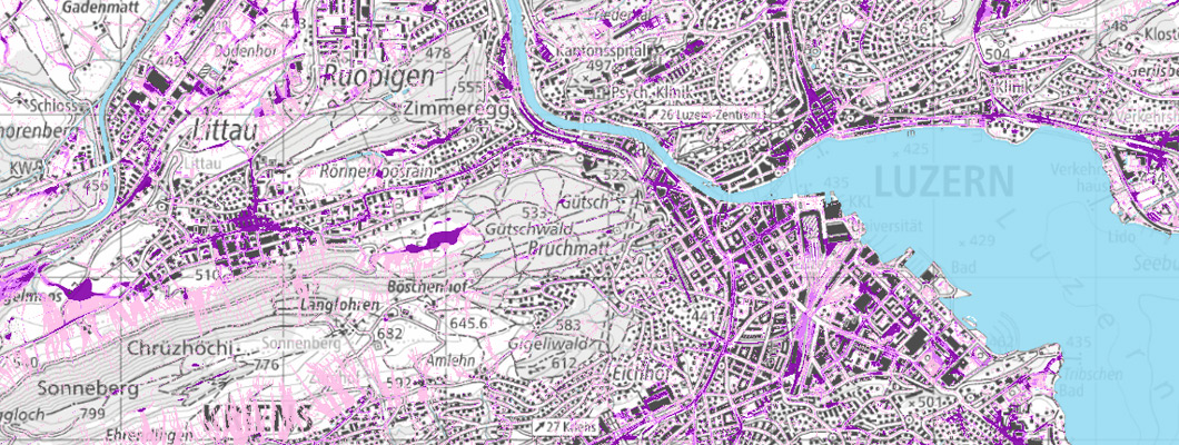
FloodArea HPC是一種軟件模型,可根據(jù)強降雨情況,河流洪水,大壩和堤防破壞來計算洪水。借助基于柵格的水動力數(shù)值模型FloodArea HPC,您可以在最高級別處理人口稠密地區(qū)和非人口稠密地區(qū)的洪水災(zāi)害。
這種高端軟件模型非常適合挑戰(zhàn)性領(lǐng)域。由于采用了計算方法,因此即使在很大的面積上也可以快速高分辨率地進(jìn)行模擬,同時保持高度的細(xì)節(jié)和有效性。綜合設(shè)置的可能性在洪水建模中考慮了地形,水文和水力方面的特殊性。
可以不受限制地組合水位,點注入和灑水功能:在模擬的任何時間,數(shù)據(jù)都可以在時間和空間上變化。設(shè)置選項為您提供了方案設(shè)計方面的完全控制權(quán)和靈活性-并使您可以建模得更接近實際。
洪水泛濫的模擬:氣候變化的一個日益重要的方面。FloodAreaHPC已經(jīng)在許多項目中顯示了其優(yōu)勢。
洪水災(zāi)害圖:防洪必不可少的地圖。用戶欣賞仿真速度和仿真結(jié)果的清晰度。
堤防違規(guī)建模:軟件模型的強大計算性能與預(yù)仿真相結(jié)合,使得堤防違規(guī)操作成為可能。
保留措施效率的模型:提供關(guān)于計劃的防止大雨或洪水的措施是否會達(dá)到預(yù)期效果的確定性。
● 淹沒區(qū)域和淹沒深度的流體動力學(xué)建模
● 大壩和堤壩泄漏的模擬
● 在空間上可變的水位或水文圖上進(jìn)行/去除高達(dá)500點
● 模擬具有可變徑流系數(shù)的暴雨事件(邊坡徑流危險)
● 自動生成動畫電影(.avi),以提高您的客戶的意識
● 輸出流路分析的流向
● 考慮不包括在地形模型中的流動障礙(堤防,鐵路堤壩等)
● 二維流體動力學(xué)建模
● 在任意點輸入/輸出水
● CPU和幾個內(nèi)核的并行化,可進(jìn)行快速計算
● 與水位有關(guān)的粗糙度值或基于閾值的粗糙度值的變化
● 可選配管網(wǎng)模型cePipe,模擬下水道網(wǎng)絡(luò)
● 同時為不同分區(qū)使用多個降水水位圖
● 模擬過程中徑流系數(shù)的時間變化
● 考慮將可變水位作為約束條件
● 可以集成水泵
● 輸出流向和流速
● 中斷和恢復(fù)仿真,以及更改參數(shù)
● 自動生成動畫電影
● 根據(jù)輸出數(shù)據(jù)生成流量曲線
● ArcGIS的? 集成
● 支持集成到自動化流程(模型構(gòu)建器,批處理腳本等)中
FloodAreaHPC 11 is the next generation of
the established software model for the
calculation of floods. Thanks to the
complete renewal, you get more
functionalities and the integration of a
sewer network model in addition to more
performance and better handling:
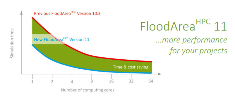
+ Optimization of computing
performance: Enables you to model
even larger areas and to complete
your projects even faster. Each
doubling of computing cores doubles
your modeling speed.
+ Flexible combination of all
FloodAreaHPC functionalities: This
allows you to design the complexity of
your scenarios as required.
+ Water level-dependent roughness: It is
now possible to change the roughness
above a threshold value — You can
Also model roughness changes due to
a rise of the water level, for example in
case of dike breaches or linear flow
processes.
+ Variable water level over time is
possible: Modelling of increasing and
decreasing water levels in a water
body.
+ Simultaneous use of several
precipitation hydrographs in the
project area: Sprinkle any number of
separate subareas with different
hydrographs, for example to display
pluviometers or grid cells of a radar
image. You can simulate dynamic
(temporal and spatial) events with
detailed precipitation data.
+ Temporal variation of runoff
coefficients: No external scripting is
required for changing the runoff
coefficients over time. This makes your
simulation more stable and faster and
it also reduces rounding errors to
almost zero.
+ New file formats: better readability
and therefore better handling and
fewer errors when creating these files.
+ Elimination of separate pre-processing:
Everything is integrated into the model
core, this makes processing faster and
more stable.
+ Coupling with sewer model: If the
sewer system has a high influence on
your modeling task, simply couple
FloodAreaHPC with cePipe.
+ More output information:
FloodAreaHPC provides important
values for error checking and thus for
optimizing your quality control.
+ Web-based manual: Always access the
latest version and easy to use.
+ New price list: The multi-core versions
got cheaper. You get even more
performance for your money. With an
update subscription you save an
additional 25% of the update fee
● ArcGIS 版本 10.5 或更高版本
● 一臺裝有 Windows 10 或更高版本的電腦
● 至少 2 GB 主內(nèi)存。
可編輯柵格圖層的大小取決于可用的主內(nèi)存。增加虛擬主內(nèi)存的大小并不能解決這個問題,因為增加虛擬主內(nèi)存的使用會大大降低計算速度。所需的硬盤存儲在很大程度上取決于模擬的中間輸出步驟(以 GeoTIFF 的形式)的數(shù)量和大小。
 北京友萬信息科技有限公司,英文全稱:Beijing Uone Info&Tech Co.,Ltd ( Uone-Tech )是中國大陸領(lǐng)先的教育和科學(xué)軟件分銷商,已在中國300多所高校建立了可靠的分銷渠道。擁有最成功的教學(xué)資源和數(shù)據(jù)管理專家。如需申請軟件采購及老版本更新升級請聯(lián)系我們,咨詢熱線:010-56548231 ,咨詢郵箱:info@uone-tech.cn 感謝您的支持與關(guān)注。
